
 The history of The Ballot Box is a work in progress. Researching this information is a lot like doing a human's genealogy; it involves researching deeds backward in time. Most houses don't move their locations for the life of the structure so the hunt involves researching the parcel of land that the house was built on. But in this case the house was moved, so there is a HOUSE history and a LAND history, and they're not the same!
This is what we know so far (going backward in time for each one)...
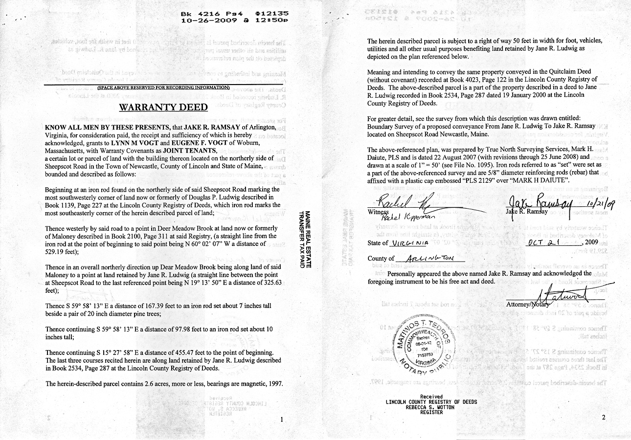
2009 - SALE: from RAMSAY to VOGT
On October 23rd 2009, a wonderful little renovated carriage house was sold to Lynn and Gene VOGT, and became known as The Ballot Box!
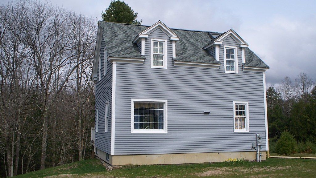 The house, and 2.6 acres (more or less) of land in Newcastle Maine, was sold by Jake Ramsay to the VOGTs (Book 4216, Pages 4-5). The house had been moved to this spot from a previous location in Damariscotta in 2007, dropped onto a new foundation, had a new potable fresh water well drilled (407 foot well, with a 7 gpm pump), a new septic system put in place, all new plumbing, a new 100 amp electric service, two new Rinnai propane heaters, and lots of new interior things (walls, doors, some windows, two new dormers, new upstairs bathroom, etc.). It was totally renovated, so it has the 1860s charm of a carriage house (with wide pine floors, exposed beam ceilings, and the original carriage house sliding door still attached for effect), but it's new! It is effectively a new house, with the charm of an antique! The Ballot Box!
2007 - SALE of building, not land: HERVOCHON to RAMSAY
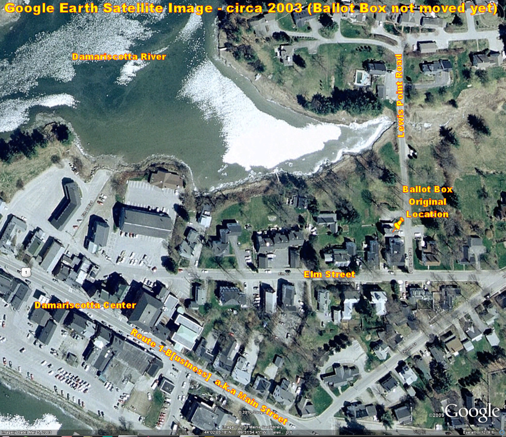
 Sometime in 2007, a carriage house on the shores of the Damariscotta River in downtown Damariscotta Maine (but not the land it was on!) was sold by its owner, George F. Hervochon to Jake Ramsay, who then had it moved to its current location in Newcastle Maine. It was located behind a large house made up of condominiums on the corner of Elm Street and Lewis Point Road in Damariscotta Maine, and the carriage house blocked the view of the river for the condominiums, so it had to go! They literally picked it up and moved it 3.6 miles to a 2.4 acre plot of land in Newcastle. Portland TV Station WCSH-6 filmed the move and had the film clip on its web site for a while, but it has since been removed. I spent about a year trying to get a copy of the video, and finally got a copy from the WCSH archives (52 second clip, no narrative, 7.1 MB WMV file).
The move - and the improvement to the remaining condos' view - was also a prime focus for a real estate posting on a local real estate company's web site at the time:
A great listing just got better. The Elm Street Condominiums in Damariscotta recently "lost" the carriage house which had stood between the main building and the water behind the property. This was a long planned move but is still is amazing how much the view has been opened up and the back of the building and yard is filled with light.
I always find it impressive watching buildings being moved and apparently so do a lot of other people as the job attracted a small crowd of onlookers and even a videographer from Channel 6 in Portland. ... watch the video of the carriage house going down Route 1 to its new home in Sheepscot...
In early March 2010 I wrote an email to the person who owned the house at its previous location asking about its previous "life," and received a reply from his daughter on St. Patrick's Day 2010, giving us more information and pre- and trans-move pictures of the house. The email is as follows:
Hi Gene,
Sorry it has taken me forever to get back to you....... I got your email right before that storm. We lost power for a few days and then I just lost track of it.... I can answer most of the questions that you have. I have attached all the pictures I took the day of the move. The carriage house was on the corner of Elm Street and Lewis Point Road in Damariscotta. We completely renovated the main house on the property that was 4 apartments when we bought the property around 1987. When we renovated we sold the units as condos and in the contracts was the fact that we would relocate the carriage house since it was very close to the main building and blocked views of the river. The carriage house was very run down when we bought the property but my mom and dad completely renovated that in the early 90's. Lifting it up putting a foundation underneath it and making it into a rental unit.
I have more pictures of the inside that we used to advertise the building for sale that I will send in another email. I also think I have the link to the news coverage of the building move. That will take a little more digging to find.
I will send along more answers as I think of them. Glad you are enjoying the Carriage house. It is a great building and the property it was moved too is really lovely too.
Best,
Anni
The before pictures, and pictures of the move, are on the PHOTOS page.
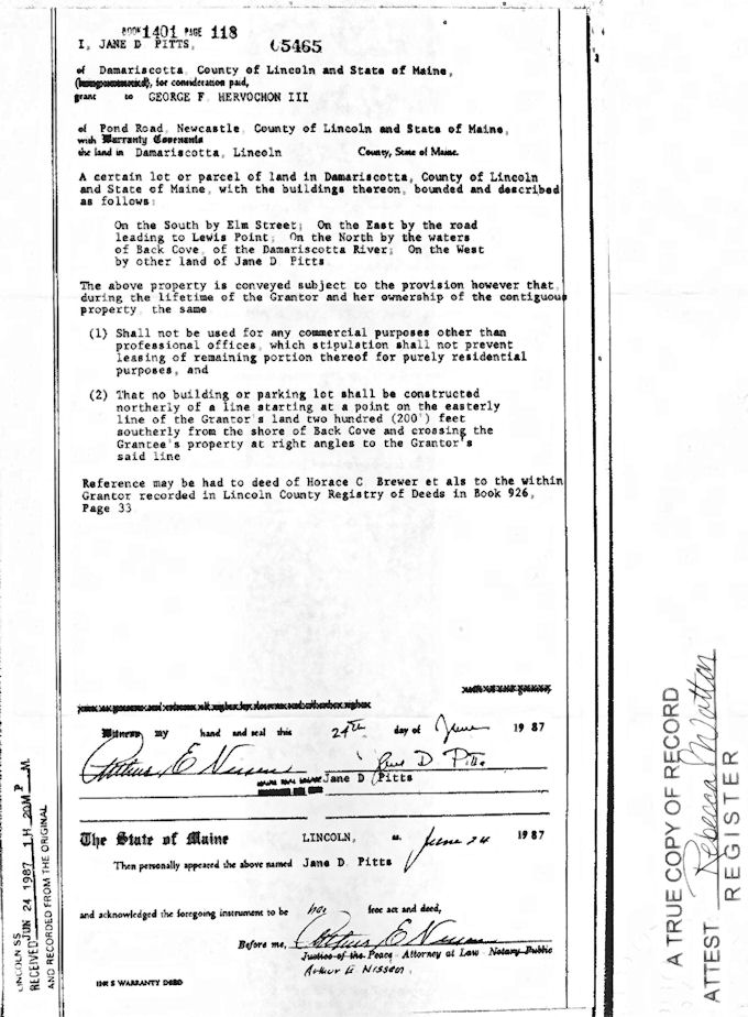
1987 - SALE: PITTS to HERVOCHON
A large house and accompanying carriage house on the corner of Elm Street and Lewis Point Road in Damariscotta was purchased by George F. Hervochon, a local builder/architect, from Jane D. Pitts on June 24, 1987 (Lincoln County ME Registry of Deeds, Book 1401, Page 118). The large house had been broken up into four apartments sometime in the past and was renovated by the new owner into four condominiums which were sold with the promise that the carriage house would eventually be relocated since it blocked the views of the Damariscotta River for the condominiums.
The most recent description of the original location is from the 1987 deed:
A certain lot or parcel of land in Damariscotta, County of Lincoln and State of Maine, with the buildings thereon, bounded as described as follows: On the South by Elm Street; On the East by the road leading to Lewis Point; On the North by the waters of Back Cove, of the Damariscotta River; On the West by other land of Jane D. Pitts.
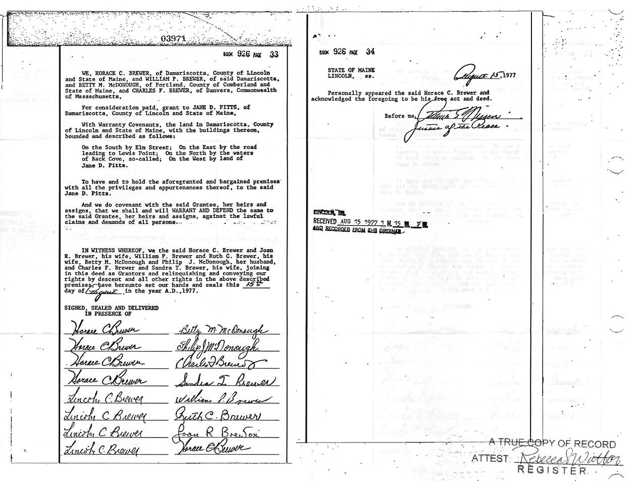
1977 - SALE: BREWER et al to PITTS
The large house and the carriage house that was with it were purchased on the 15th of August 1977 by Jane D. Pitts from three members of the Brewer family (Charles F., Horace C., and William P.) and from Betty M. McDonough (Lincoln County ME Registry of Deeds, Book 926, pages 33 & 34). Jane D. Pitts is also listed on the deed as owning the land to the west of the parcel being sold. Speculation on my part, but it looks like it was an estate sale by the children of the deceased.
On 30 December 2010, I spent about 4 hours at the Lincoln County ME Registry of Deeds in Wiscasset, doing direct research on the deeds and associated filings for the property in Damariscotta that contained the carriage house that became the Ballot Box. The following details are the fruits of that research visit.
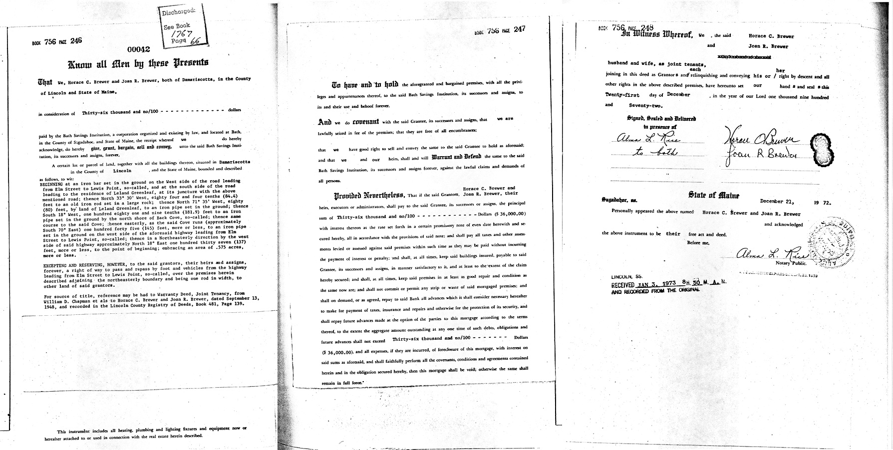
1972 – MORTGAGE: BREWERs
The Brewers (Horace C. and Joan R.), owners of the property at the corner of Elm Street and Lewis Point Road, took out a mortgage on 21 December 1972 (recorded at the Lincoln County ME Registry of Deeds, Book 756, pages 246-248), for purposes undocumented, in the amount of $36,000. The Mortgage has a clear description of the property:
BEGINNING at an iron bar set in the ground on the west side of the road leading from Elm Street to Lewis Point, so-called, and at the south side of the road leading to the residence of Leland Greenleaf, at its juncture with the above-mentioned road; thence North 33º 30’ West, eighty four and four tenths (84.4) feet to an old iron rod set in a large rock; thence North 71º 35’ West, eighty (80) feet, by land of Leland Greenleaf, to an iron pipe set in the ground; thence South 18º West, one hundred eighty one and nine tenths (181.9) feet to an iron pipe set in the ground by the north shore of Back Cove, so-called; thence same course to the said Cove; thence easterly, as the said Cove runs (approximately South 70º East) one hundred forty five (145) feet, more or less, to an iron pipe set in the ground on the west side of aforesaid highway leading from Elm Street to Lewis point, so-called; thence in a Northeasterly direction by the west side of said highway approximately 18º East one hundred thirty seven (137) feet, more or less, to the point of the beginning; embracing an area of .575 acres, more or less.
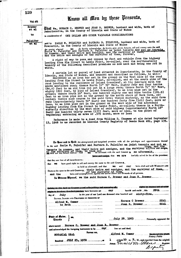
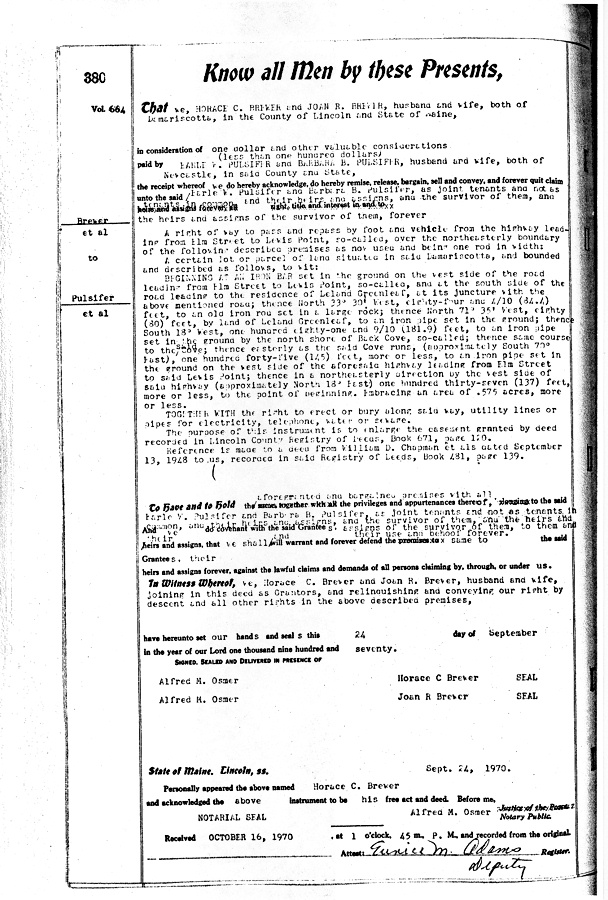
1970 / 1965 – RIGHT-Of-WAY granted, from BREWERs to PULSIFERs
In 1965 (Book 671, page 120), and again in 1970 (Book 664, page 380; yes the 1965 recording was in a later book than the 1970 recording; I don’t understand it either) the Brewers (Horace C. and Joan R.) deeded to Earle W. and Barbara B Pulsifer … a Right-Of-Way to pass and repass by foot and vehicle from the highway leading from Elm Street to Lewis Pont, so-called, over the northeasterly boundary of the following described premises as now used and being one rod in width. Following the right-of-way description was a description of the property that was word-for-word identical to the property description from the 1972 mortgage. The 1970 right-of-way added the right to … erect or bury along said way, utility lines or pipes for electricity, telephone, water or sewage.
1948 – SALE: from CHAPMANs to BREWERs
On 17 September 1948, William D Chapman, Gladys C. (nee Chapman) Brewer, Martha C. (nee Chapman) Belknap and Emily Chapman sold to Horace C. and Joan R. Brewer (Book 481, pages 139-141) the property described as:
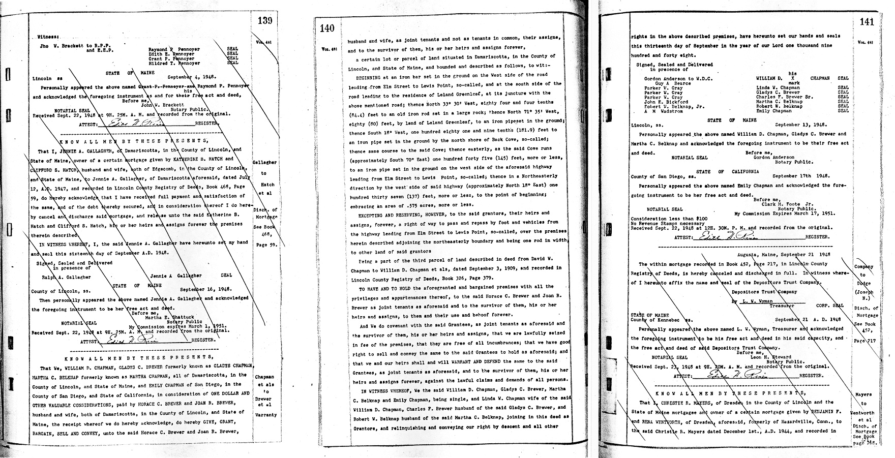
BEGINNING at an iron bar set in the ground on the west side of the road leading from Elm Street to Lewis Point, so-called, and at the south side of the road leading to the residence of Leland Greenleaf, at its juncture with the above-mentioned road; thence North 33º 30’ West, eighty four and four tenths (84.4) feet to an old iron rod set in a large rock; thence North 71º 35’ West, eighty (80) feet, by land of Leland Greenleaf, to an iron pipe set in the ground; thence South 18º West, one hundred eighty one and nine tenths (181.9) feet to an iron pipe set in the ground by the north shore of Back Cove, so-called; thence same course to the said Cove; thence easterly, as the said Cove runs (approximately South 70º East) one hundred forty five (145) feet, more or less, to an iron pipe set in the ground on the west side of aforesaid highway leading from Elm Street to Lewis point, so-called; thence in a Northeasterly direction by the west side of said highway approximately 18º East one hundred thirty seven (137) feet, more or less, to the point of the beginning; embracing an area of .575 acres, more or less.
(Identical wording to the 1972 mortgage and 1970 and 1965 Right-Of-Way).
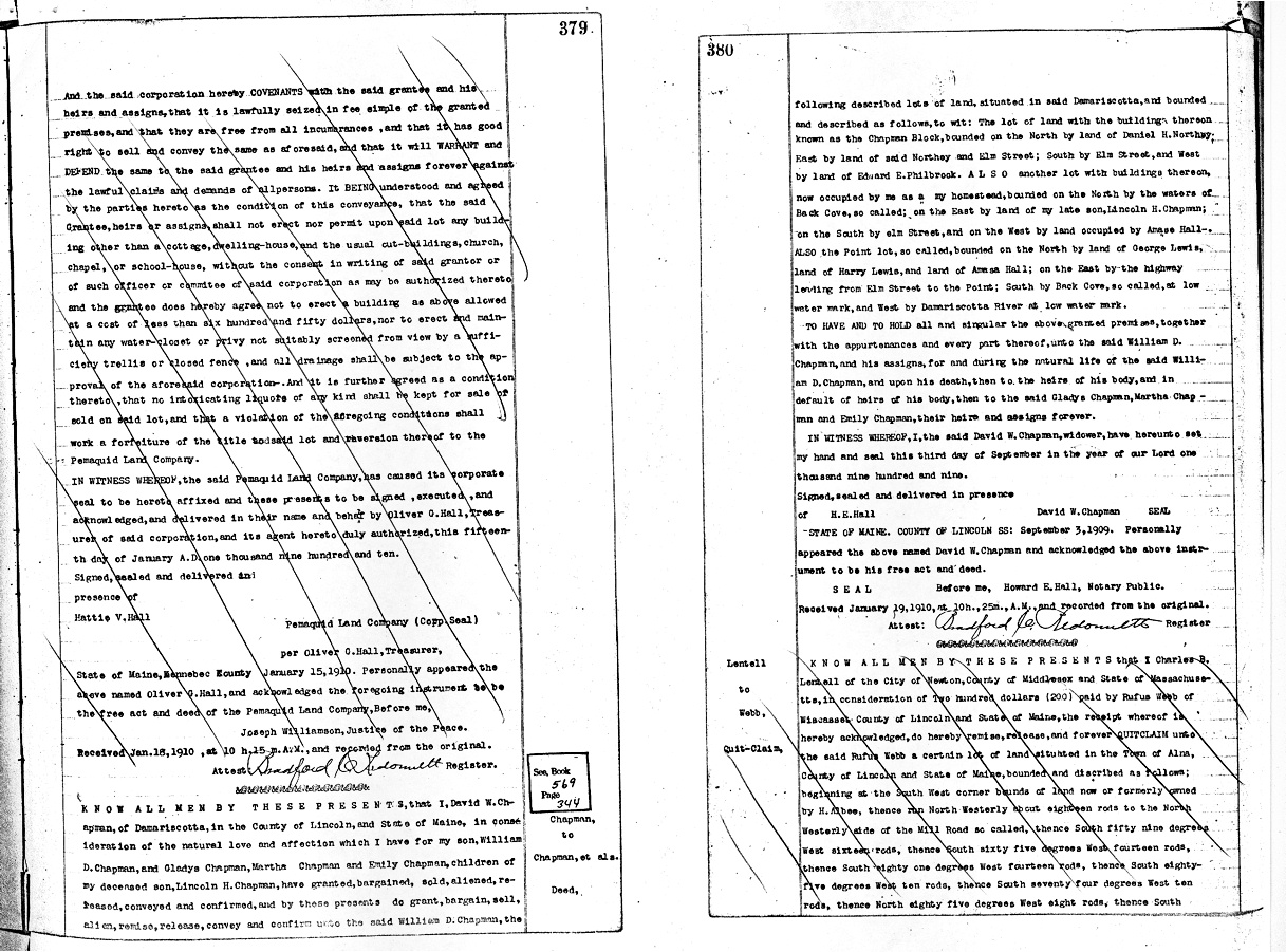
1909 – SALE/CONVEYANCE: from CHAPMAN to CHAPMANs
On 3 September 1909 (Book 326, pages 379 & 380), widower David W. Chapman conveyed (for no apparent cash value) to his son William D. Chapman and his grand-daughters Gladys, Martha, and Emily Chapman (daughters of David’s deceased son Lincoln H. Chapman) three plots of land with buildings in Damariscotta ME: The so-called "Chapman" Block on Elm Street, and
…another lot with buildings thereon, now occupied by me as my homestead, bounded on the North by the waters of Back Cove, so called, on the East by land of my late son, Lincoln H Chapman; on the South by Elm Street, and on the West by land occupied by Amasa Hall -
and
…the Point lot, so called, bounded on the North by land of George Lewis, land of Harry Lewis, and land of Amasa Hall; on the East by the highway leading from Elm Street to the Point, South by Back Cove, so called, at low water mark, and West by Damariscotta River at low water mark.
These lot descriptions are amazingly vague, lacking the angles and distances between distinct points (often iron rods) in later deeds, but the references appear to match up when the last two lot descriptions are considered and possibly combined and re-divided. Earlier deeds are equally interesting.
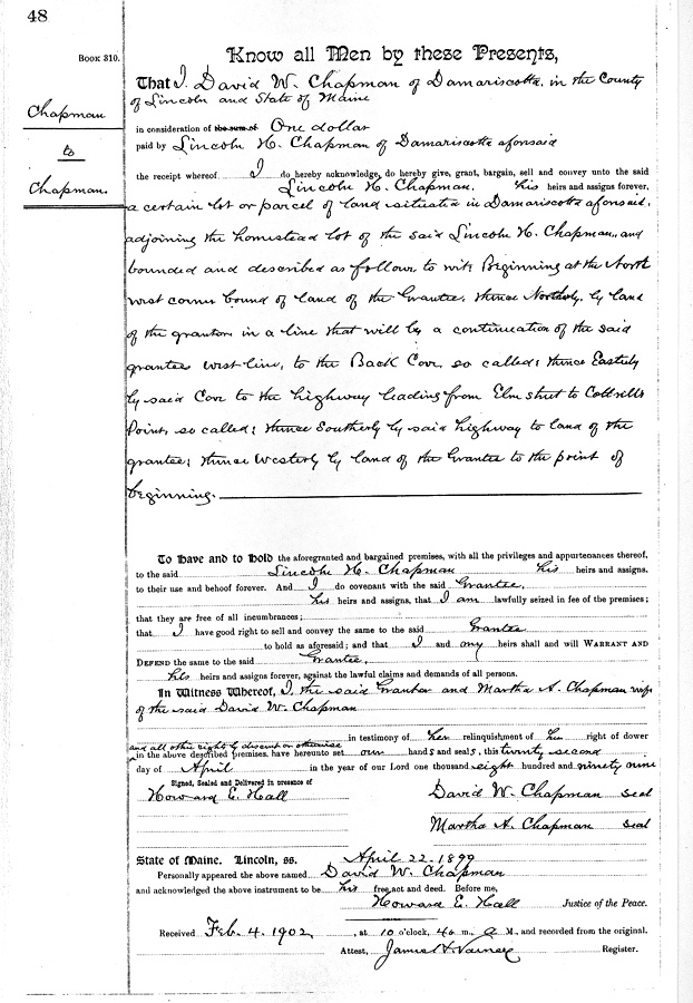
1899 – SALE/CONVEYANCE: from David CHAPMAN to Lincoln CHAPMAN
Father David W. Chapman sold to son Lincoln H. Chapman, in consideration of one dollar (Book 310, page 48), the following plot of land:
…situated in Damariscotta aforesaid, adjoining the homestead lot of the said Lincoln H. Chapman, and bounded and described as follows, to wit: Beginning at the Northwest corner bound of land of the Grantee, thence Northerly, by land of the grantor in a line that will be a continuation of the said grantee west line, to the Back Cove, so called, thence Easterly by said Cove to the highway leading from Elm Street to Cottrill’s Point, so called, thence Southerly by said highway to land of the grantee; thence Westerly by land of the Grantee to the point of beginning.
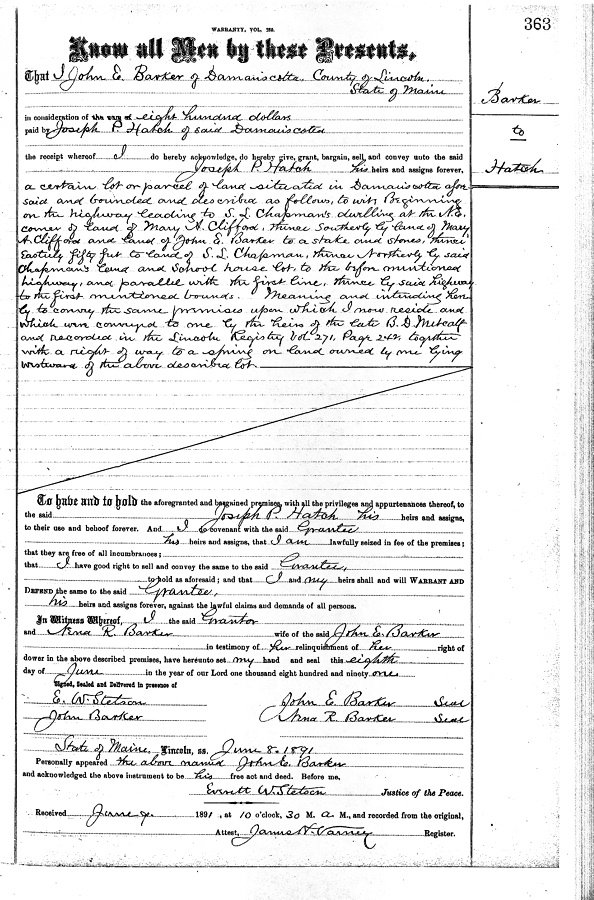
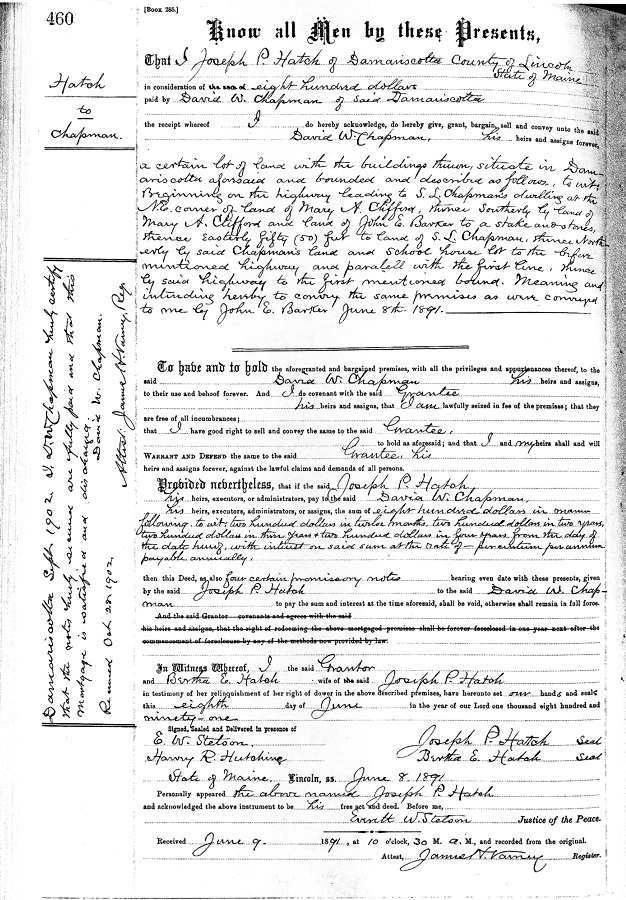
1891 – DOUBLE SALE: from BARKER to HATCH, then from HATCH to CHAPMAN
On 8 June 1891, a real estate transaction of unusual methods occurred. A "...lot of land with buildings..." was sold twice on the same day; first from John E. and Irma R. Barker to Joseph P Hatch for $800 (Book 289 page 363), then from Joseph P. and Bertha E. Hatch to David W. Chapman again for $800 (Book 285 page 460). Descriptions of the property are identical, with only the source and intent portion at the end differing. Property description was as follows:
…beginning on the highway leading to S. L. Chapman’s dwelling at the N.E. corner of land of Mary A. Clifford, thence southerly by land of Mary A. Clifford and land of John E. Barker to a stake and stones, thence Easterly fifty feet to land of S. L. Chapman, thence Northerly by said Chapman’s land and school house lot, to the before mentioned highway, and parallel with the first line, thence by said highway to the first mentioned bound.
The first deed (from BARKER to HATCH) concludes as follows:
Meaning and intending hereby to convey the same premises upon which I now reside and which were conveyed to me by the heirs of the late B. D. Metcalf and recorded in the Lincoln Registry Vol. 271, Page 242, together with a right of way to a spine of land owned by me lying westward of the above described lot.
The second deed (from HATCH to CHAPMAN) concludes as follows:
Meaning and intending to convey the same premises as were conveyed to me by John E. Barker June 8th, 1891.
Infinite speculation can be made as to why the odd double-sale would occur. Perhaps the land could not be directly sold to a Chapman for some reason, so it had to take this double-hop.
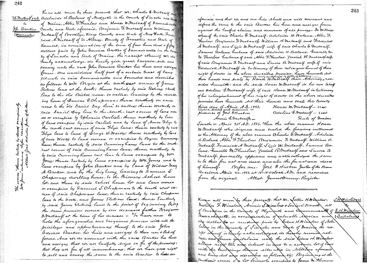
1883 – SALE: from estate of Benjamin D. METCALF to John Edward BARKER
On 3 April 1883, the heirs of the estate of Benjamin D. Metcalf (Charles E. Metcalf and Adelaide H. Boland of Newcastle, Lincoln County, Maine; Abbie F. Thurlow and Horace W. Metcalf of Damariscotta, Lincoln County Maine; Benjamin F. Metcalf and William H. Metcalf of Brooklyn, Kings County, New York; and Frederick A. Metcalf of St. Albans, Franklin County, Vermont) sold to John Edward Barker "…one undivided half part of a certain tract of land situated in Damariscotta…", for the sum of $450, the property described below (Book 271 Pages 242-243):
Begin at the Northwest corner of James Stetson’s land at the brook; thence easterly by said Stetson’s brook line to the old Bristol Road, so called, leading to the dwelling house of Duncan D. Chapman; thence Southerly on said road to the “old Daniel Day line,” so called, thence westerly on said Daniel Day line to the South-east corner of land owned or occupied by Ephraim Carlisle; thence Northerly by line of land occupied by said Carlisle and by land of Amos Fly’s to the North east corner of said Fly’s land; thence Westerly by said Fly’s land to land of George H. Weeks; thence Northerly by land of said Weeks to land owned or occupied by Byron Cunningham; thence Easterly by said Cunningham’s land to the Southeast corner of said Cunningham’s land; thence Northerly by said Cunningham’s east line to land occupied by Wm Jones; thence Easterly by land occupied by Wm Jones and by land occupied by John Barker and by land of Widow Mary A. Barker, and by the highway leading to Samuel S. Chapman’s dwelling house, to the Primary School house lot, and thence by said school house lot and land owned or occupied by Samuel S. Chapman to the south west corner of said Chapman’s land; thence easterly by said Chapman’s land to the brook, and James Stetson’s land; thence Southerly by said James Stetson’s land to the point of beginning, being the same premises owned by our deceased father Benjamin D. Metcalf at the time of his decease.
On 10 March 1883, Abbie F. Thurlow (one of the heirs of the estate listed above) had previously sold to John Edward Barker for a similar $450 "…one undivided half part of a certain tract of land situated in Damariscotta…" (Book 270 Page 536) which was bounded and described exactly as was the land above, so it appears that with these two "half part" sales the ownership of the tract of land was consolidated under John Edward Barker.
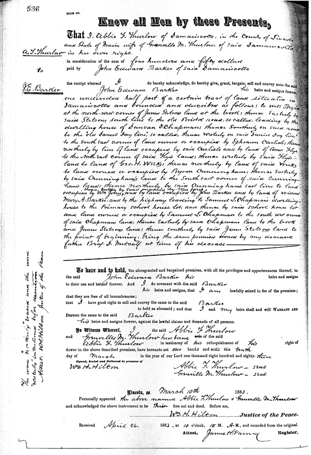
Note that this registered land sale does not include the phrase "with buildings" or any equivalent, so I am speculating that the house and carriage house was built on the land by John E. Barker sometime between April 1883 and June 1891.
The structure is rumored to have originally been built in the 1860's as a true carriage (as in "horse and carriage") house, on the shores of the Damariscotta River.
2008 - CONVEYANCE: from LUDWIG to RAMSAY
On June 26, 2008, Jane Ludwig conveyed to her son, Jake Ramsay, a 2.6 acre (more or less) parcel of land (Book 4023 Page 122 thru 124) that was carved out of a 15 acre parcel of land owned by Jane Lugwig. The property is described as follows:
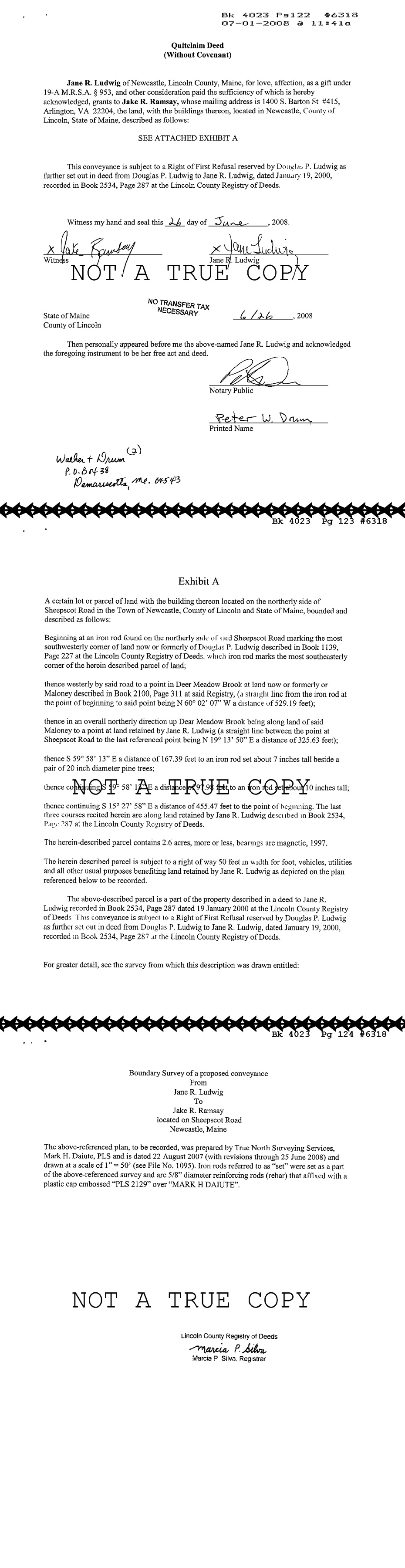
A certain lot or parcel of land with the building thereon located on the northerly side of Sheepscot Road in the Town of Newcastle, County of Lincoln and State of Maine, bounded and described as follows:
Beginning at an iron rod found on the northerly side of said Sheepscot Road marking the most southwesterly corner of land now or formerly of Douglas P. Ludwig described in Book 1139, Page 227 at the Lincoln County Registry of Deeds, which iron rod marks the most southeasterly corner of the herein described parcel of land;
thence westerly by said road to a point in Deer Meadow Brook at land now or formerly of Maloney described in Book 2100, Page 311 at said Registry (a straight line from the iron rod at the point of beginning to said point being N 60° 02' 07" W a distance of 529.19 feet);
thence in an overall northerly direction up Deer Meadow Brook being along land of said Maloney to a point at land retained by Jane R. Ludwig (a straight line between the point at Sheepscot Road to the last referenced point being N 19° 13' 50" E a distance of 325.63 feet);
thence S 59° 58' 13" E a distance of 167.39 feet to an iron rod set about 7 inches tall beside a pair of 20 inch diameter pine trees;
thence continuing S 59° 58' 13" E a distance of 97.98 feet to an iron rod set about 10 inches tall;
thence continuing S 15° 27' 58" E a distance of 455.47 feet to the point of beginning. The last three courses recited herein are along land retained by Jane R. Ludwig described in Book 2534, Page 287 at the Lincoln County Registry of Deeds.
2000 - CONVEYANCE: from LUDWIG to LUDWIG
On January 19, 2000, Douglas Ludwig conveyed (Book 2534, Pages 287 & 288, by virtue of divorce) to his ex-wife, Jane Ludwig, a 15 acre parcel of land on Sheepscot Road in Newcastle Maine, from which the 2.6 acre parcel was carved in 2008.
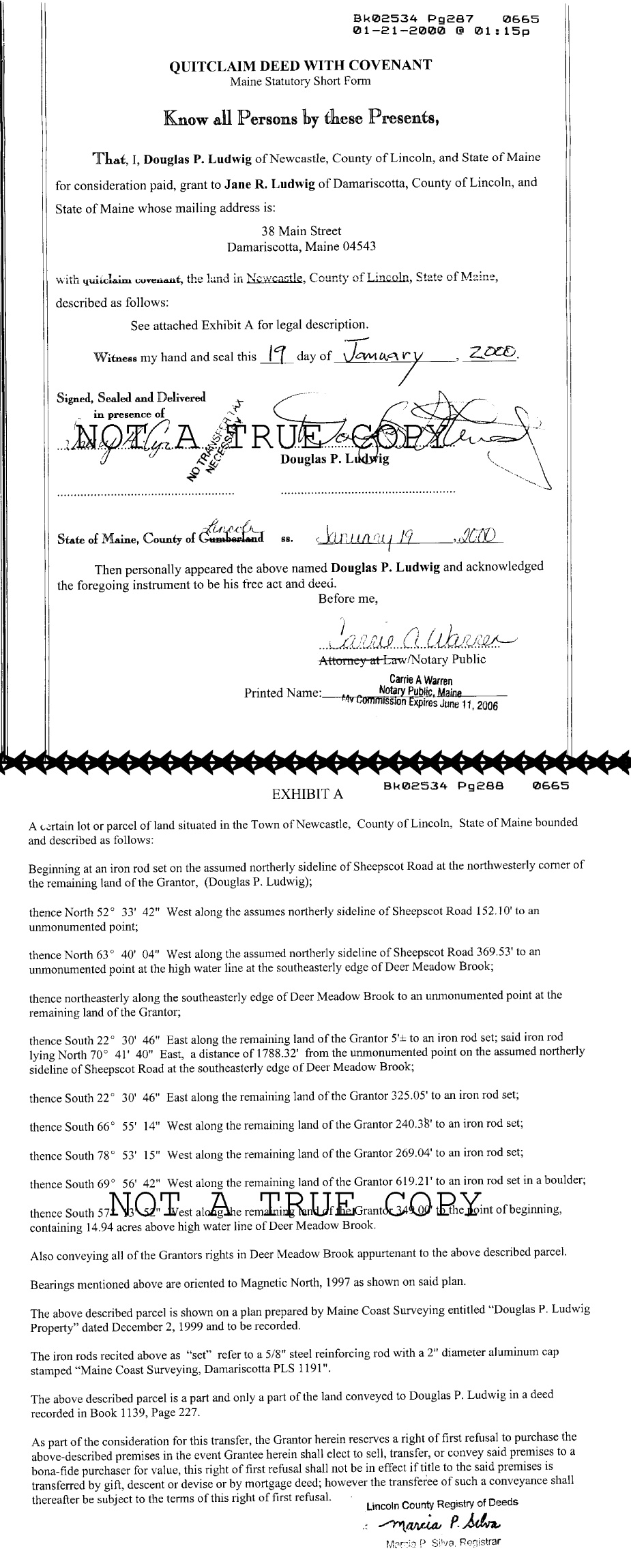
1983 - INHERITANCE DISTRIBUTION: from LUDWIG to LUDWIG
On May 9, 1983 (Book 1139, Page 227), the estate of Janice P. Ludwig granted to Douglas P. Ludwig the real property in Newcastle, Lincoln County, Maine, described as follows:
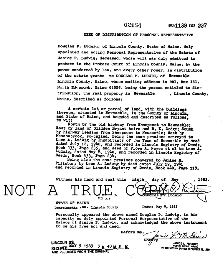
A certain lot or parcel of land, with the buildings thereon, situated in Newcastle, in the County of Lincoln, and State of Maine, and bounded and described as follows, to wit:
North by the old highway from Sheepscot to Newcastle; East by land of Glidden Bryant heirs and B.K. Dodge; South by highway leading from Sheepscot to Newcastle; West by Meadowbrook, so-called. Being the same premises conveyed to Leon A. Ludwig by Inhabitants of the Town of Newcastle by deed dated July 12, 1940 and recorded in Lincoln Registry of Deeds, Book 433, Page 235, and deed of Flora A. Noyes et al to Leon A. Ludwig, dated May 8, 1940 and recorded in Lincoln Registry of Deeds, Book 433, Page 234.
Being also the same premises conveyed to Janice M Pillsbury by Leon A. Ludwig by deed dated July 19, 1941 and recorded in Lincoln Registry of Deeds, Book 440, Page 118.
1941 - CONVEYANCE from LUDWIG to PILLSBURY
On July 19, 1941 (Book 440, Page 118)
1940 - CONVEYANCE from ????? to LUDWIG
On July 12, 1940 (Book 433, Page 235)
1940 - CONVEYANCE: from NOYES to LUDWIG
On May 8, 1940 (Book 433, Page 234)
We will fill in more gaps as we find out more information...
Copyright © 1973-2023 by Eugene F. Vogt. All rights reserved. Last modified 02-Jan-2023 1:24 PM ET. Send questions or comments to the Family TreeHouse WebMeister. View our Privacy Policy.